Recovery.gov Augmented Reality Mashup
As of today Android and iPhone 3GS users can see recovery.gov contract data on their phones via the Layar augmented reality application. Layar is an application that overlays your view of the real world with waypoints representing your favorite coffee place, the movie theatre you’re trying to find, or in this case, where some of that $787 billion from the American Recovery and Reinvestment Act is going.
If you have an iPhone 3GS or Android device you can install the Layar app for free and then search for “recovery” or “sunlight” within Layar to find this layer. The layer works best near large cities where you are most likely to find recovery contracts, below is an example of what it looks like on the streets of Washington DC.
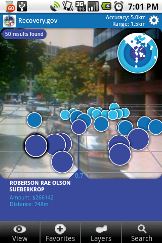
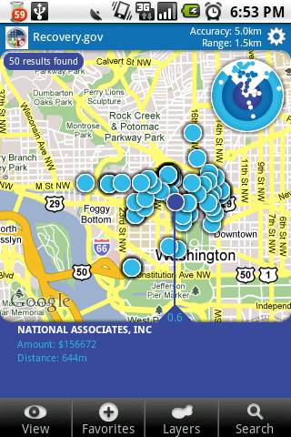
There are also a few options to help you filter the results should you be in a contract-heavy area like DC, it is possible to filter by amount or search by name if you’re trying to find larger contracts or contracts for a certain nearby recipient.
This data is taken from the recovery.gov Where Is The Money Going? map which provides a KML file containing all recipient reported Contracts. As of October 30th this data will be updated with the final contract, grants, and loans.
How We Made It
If you’re a developer you might be interested in how we made this. Fortunately Layar makes it quite easy and we’ve taken a further step to make it even easier if you’re already using Django.
The first step was just a quick script to load the data from this KML file into a PostGIS database. Once the data was in a database I developed a reusable Django application that makes it easy to serve data in the format that Layar expects. The reusable Django application we’ve made available as django-layar.
If you want to see the specific usage of django-layar that powers this particular layer it is short and simple: