OpenGov Voices: Mapping city boundary change over time with open data
In May, 2014, the Sunlight Foundation awarded us an OpenGov Grant to support our OpenBoundaries Initiative – a project we started with the simple but audacious goal of mapping out how every municipality in the world has evolved over space and time and loading this open data into the MapStory.org global data commons for the world to see, share and improve upon.
Why do such a thing? Our initial motivation was to support urban historians and genealogists who need to know this information but who currently spend inordinate amounts of time searching historic maps and city records for it. In the digital age, citizens should be able to ask and immediately answer, this simple question: how has the geography of my city/town/borough/village changed throughout its history?
Our effort started in New York state, where we successfully collected, processed and mapped nearly every municipal annexation to occur in the state since 1625. That data is now available for use as “StoryLayers” in mapstory.org. For example, see:
The Sunlight grant enabled us to expand the project to California. We were interested in California because of its obvious size and because of a recent State Supreme Court ruling that all local GIS data is indeed “public” data open to citizens to request and use. Since we started working on California in June, we’ve obtained data for about 100 of the 500 cities across the state. These are, for the most part, the cities that had their historical annexation data prepped and ready to easily share. The remaining cities may have the data but not publicize it, may want to charge for it, or may need a few volunteers to turn analog data on old maps into digital files … and that’s what we’re here for!
One interesting example of our effort so far comes from Sacramento. The source annexation data for this city existed, but was not available on the city’s website. So we contacted staff from the IT department and they happily provided it. Sacramento is the first California city to be processed and uploaded into the MapStory.org site as part of the Open Boundaries Initiative. During processing we discovered that Sacramento annexed a smaller city in 1964 called North Sacramento. Research into that now defunct city’s annexation history is currently ongoing.
Here’s what we have so far on Sacramento:
The beauty of doing this work with MapStory is that others can use these open “StoryLayers” as part of MapStories they want to tell — perhaps dealing with issues of urban sprawl, land use, gerrymandering, etc. — or even download the raw data for further analysis in another statistical package.
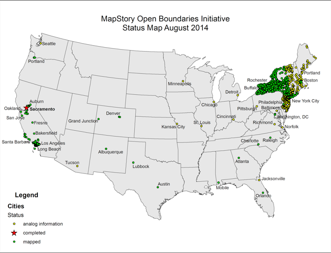
And, although our focus has been on California of late, we’ve acquired data to share elsewhere – for example on Portland, Atlanta, Charlotte, Raleigh, Austin, Mobile, Orlando and Denver. Here’s a map of where we we’ve gathered data from so far:
Already a number of new volunteers have joined the effort. Working together, we’re developing applications that will help to expedite the processing of public domain data into a standard format that will allow time-stamped data to be animated in MapStory.
In the long run, our goal is to expand globally. To get there, we’re looking for more volunteers who can build upon our standard data format, wrangle local communities for data and process it for sharing. When the new MapStory platform comes out later this fall, we’ll be able to manage this mass collaboration and “crowd-editing” inside that platform. For now, we’re using a lot of Google docs and a wiki page, accessible here. If you would like to get involved in this effort you can contact us at karlphillips162@gmail.com or john.vincent@zoho.com
Karl Phillips is the owner of Dynamic Geographics LLC, a Virginia based Cartographic firm. He holds a Bachelor of Individualized Study in American Geographic History from George Mason University. John Vincent is a 2014 Summer Fellow at MapStory. He recently finished a GIS certificate from the University of Washington and is now based in the Washington DC area.
Interested in writing a guest blog for Sunlight? Email us at guestblog@sunlightfoundation.com