OpenGov Voices: Fracking chemicals, open data, and government transparency

The Obama administration is on the brink of making a decision that would ignore a Presidential Executive Order, violate a flagship administration policy and inexplicably keep the public in the dark on an issue of national significance: the possible environmental and public health impacts of the current boom in hydraulic fracturing (fracking) for oil and gas.
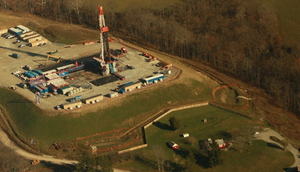
The Department of the Interior’s Bureau of Land Management (BLM) is finalizing a new rule to govern oil and gas drilling and fracking on millions of acres of public and Indian lands, from the spectacular tundra of Alaska, to the arid high plains of the Rocky Mountain West and the lush forests of the East. This “unconventional” drilling is targeting certain oil and natural-gas reservoirs in shale and sandstone formations that – until the geological one-two punch of horizontal drilling coupled with fracking came along – stubbornly refused to give up their fossil fuel treasure. Increasingly, drilling is moving into places where a lot of people live. The uncomfortable juxtaposition of farms, homes and schools with the intensive industrial activity of a modern drilling site is raising concern about possible contamination of surface and ground water and questions about the immediate and long-term exposure of local residents to the chemicals used in fracking. This concern is driving many in the public to call for complete and timely disclosure of the chemicals used at every fracking operation.

With a nod to this concern, BLM’s proposed rule includes a provision for public disclosure, identifying a website called FracFocus as the preferred platform for the public to get information about the chemicals used at every future fracking operation conducted on public and Indian lands. But this site, built and hosted by an organization funded by the oil and gas industry, is not designed or operated to provide adequate public disclosure. In fact, it doesn’t comply with fundamental requirements of the President’s May 9, 2013 Executive Order on Open Data and violates the intent and spirit of this administration’s much-ballyhooed Open Data and Open Government initiatives. The chemical information is provided in PDF format, which is not machine-readable; the information is protected by copyright; and the terms of use forbid the sharing of the PDF reports. The reports lack the most basic elements of data curation, including reporting date and version control; and the ability of users to download PDFs from the site is being systematically throttled by the site administrators. Moreover, the data are regrettably incomplete: The identification of far too many chemicals is hidden behind arbitrary trade-secret claims, with no justification provided.
Industry defenders of FracFocus have tried to brush off these repeated criticisms from NGOs, academia and the Department of Energy. But complete disclosure that facilitates the aggregation and analysis of chemical data for tens of thousands of wells nationwide over years of drilling activity, is crucial to enabling scientific investigation to answer one of the salient energy-policy questions of our generation: What, exactly, are the public health and environmental risks posed by modern drilling and fracking? BLM may claim that it’s too costly or complicated for the government to build its own site to curate this information and effectively serve it to the public, but we disagree. Other agency websites reliably provide public access to terabytes of well-curated, continually updated satellite imagery, weather data and toxic chemical information, to name just a few examples. This is a small-data problem. BLM should step up to the plate and take responsibility for collecting, curating and publishing this critical information in full compliance with Open Data and Open Government directives and intentions.
Ultimately this comes down to a fundamental question of identity for this administration: What do you stand for? Are you actually for openness and transparency in the operations of government, the management of public resources and the protection of public health and welfare? Do you stand by the President’s Executive Orders? Will you follow the excellent prescriptions and intentions of your Open Data and Open Government initiatives, promoting public participation in a strong democracy? Or will you hide crucial information from the public behind the façade of an ineffective and incomplete industry-controlled website?
This rulemaking is a gut-check opportunity. For the sake of public interest, I hope BLM and the administration get it right.
John Amos is an expert in the use of satellite images and other remote sensing data to understand and communicate local, regional and global environmental issues. Educated as a geologist at Cornell University (BS) and the University of Wyoming (MS), he spent 10 years applying image processing, image analysis, and digital mapping techniques to conduct environmental, exploration and resource assessment studies for the energy and mining industries and government entities. In 2001 he founded SkyTruth, a non-profit 501(c)(3) organization dedicated to strengthening environmental conservation by illuminating environmental problems and issues through the use of satellite images, aerial photographs, and other kinds of remote sensing and digital mapping.
Interested in writing a guest blog for Sunlight? Email us at guestblog@sunlightfoundation.com